


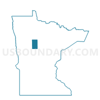
Hendrickson Twp. Voting District, Hubbard County, Minnesota
About
Outline

Summary
| Unique Area Identifier | 602548 |
| Name | Hendrickson Twp. Voting District |
| County | Hubbard County |
| State | Minnesota |
| Area (square miles) | 35.82 |
| Land Area (square miles) | 35.06 |
| Water Area (square miles) | 0.77 |
| % of Land Area | 97.86 |
| % of Water Area | 2.14 |
| Latitude of the Internal Point | 47.19313750 |
| Longtitude of the Internal Point | -94.87445370 |
Maps


Graphs
Select a template below for downloading or customizing gragh for Hendrickson Twp. Voting District, Hubbard County, Minnesota


Neighbors
Neighoring Voting District (by Name) Neighboring Voting District on the Map
- Clay Twp. Voting District, Hubbard County, MN
- Guthrie Twp. Voting District, Hubbard County, MN
- Hart Lake Twp. Voting District, Hubbard County, MN
- Lake George Twp. Voting District, Hubbard County, MN
- Lakeport Twp. Voting District, Hubbard County, MN
- Schoolcraft Twp. Voting District, Hubbard County, MN
- Steamboat River Twp. Voting District, Hubbard County, MN
- Thorpe Twp. Voting District, Hubbard County, MN
Top 10 Neighboring County Subdivision (by Population) Neighboring County Subdivision on the Map
- Lakeport township, Hubbard County, MN (845)
- Guthrie township, Hubbard County, MN (555)
- Hart Lake township, Hubbard County, MN (509)
- Lake George township, Hubbard County, MN (378)
- Hendrickson township, Hubbard County, MN (314)
- Steamboat River township, Hubbard County, MN (126)
- Schoolcraft township, Hubbard County, MN (103)
- Clay township, Hubbard County, MN (69)
- Thorpe township, Hubbard County, MN (49)
Top 10 Neighboring Unified School District (by Population) Neighboring Unified School District on the Map
- Bemidji Public School District, MN (36,502)
- Park Rapids Public School District, MN (12,088)
- Nevis Public School District, MN (2,492)
- Laporte Public School District, MN (1,764)
Top 10 Neighboring State Legislative District Lower Chamber (by Population) Neighboring State Legislative District Lower Chamber on the Map
Top 10 Neighboring State Legislative District Upper Chamber (by Population) Neighboring State Legislative District Upper Chamber on the Map
Top 10 Neighboring 111th Congressional District (by Population) Neighboring 111th Congressional District on the Map
Top 10 Neighboring Census Tract (by Population) Neighboring Census Tract on the Map
- Census Tract 701, Hubbard County, MN (4,711)
- Census Tract 702, Hubbard County, MN (2,279)
- Census Tract 703, Hubbard County, MN (1,937)